
The 10 best coastal features in Wales

Blue Lagoon , Pembrokeshire
Surrounded by the sea on three sides, Wales has 870 miles of beautiful coastal path lined arguably some of the most awe-inspiring coastal scenery in the world.
Born and raised on the Gower and having cycled around the entire coastal one of Wales over 15 days, it's safe to say Ive explored the majority of the Welsh Coast.
In this blog post I have included what I believe to be 10 of the best coastal features in Wales. From serpent shaped tidal islands to 12th century tiny stone chapels the variety and magnitude of costal scenery on show will leave you lost for words.
This list is no means definitive. With captivating coastal features hidden around every corner there are plenty of other gems not on this list to be discovered.
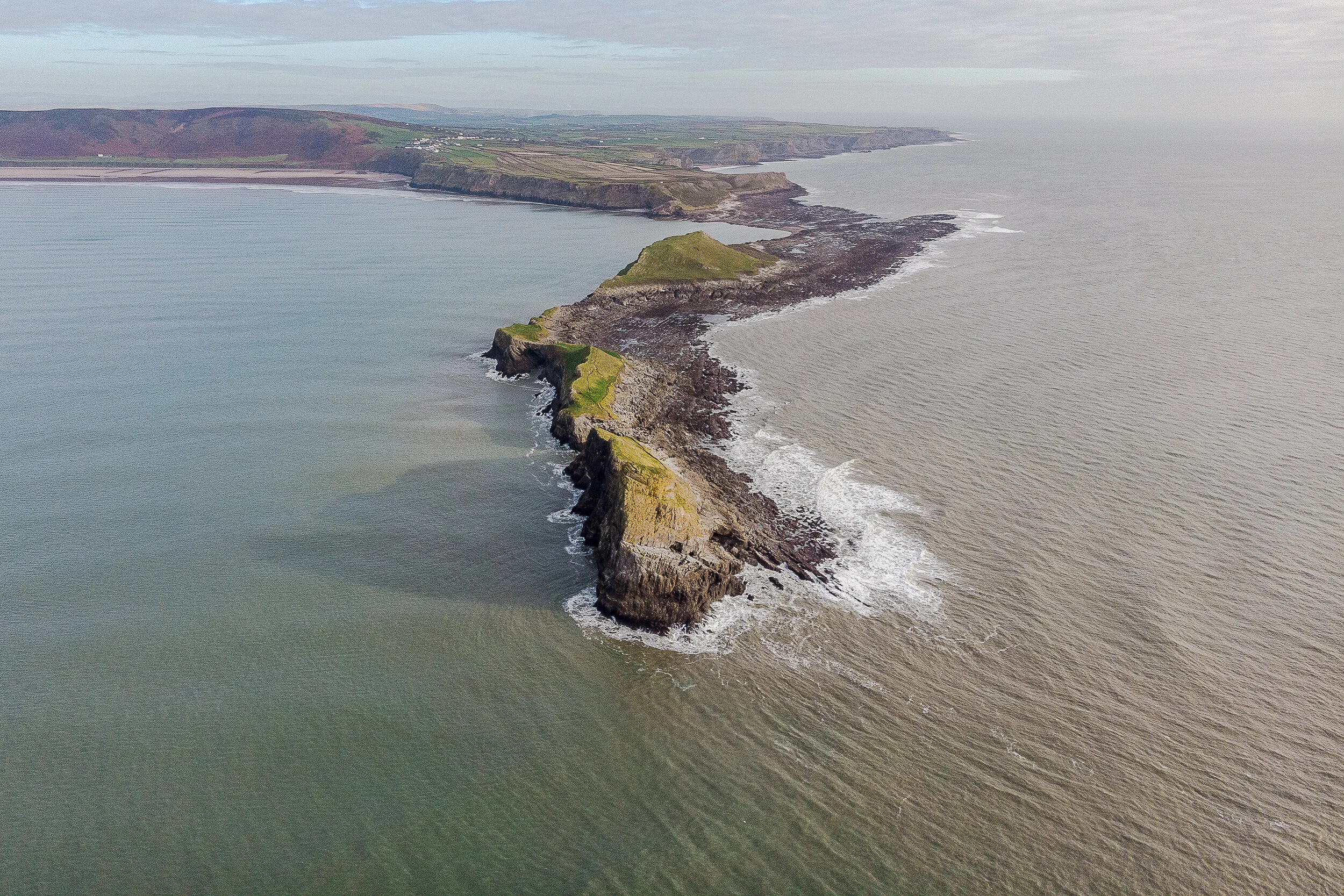
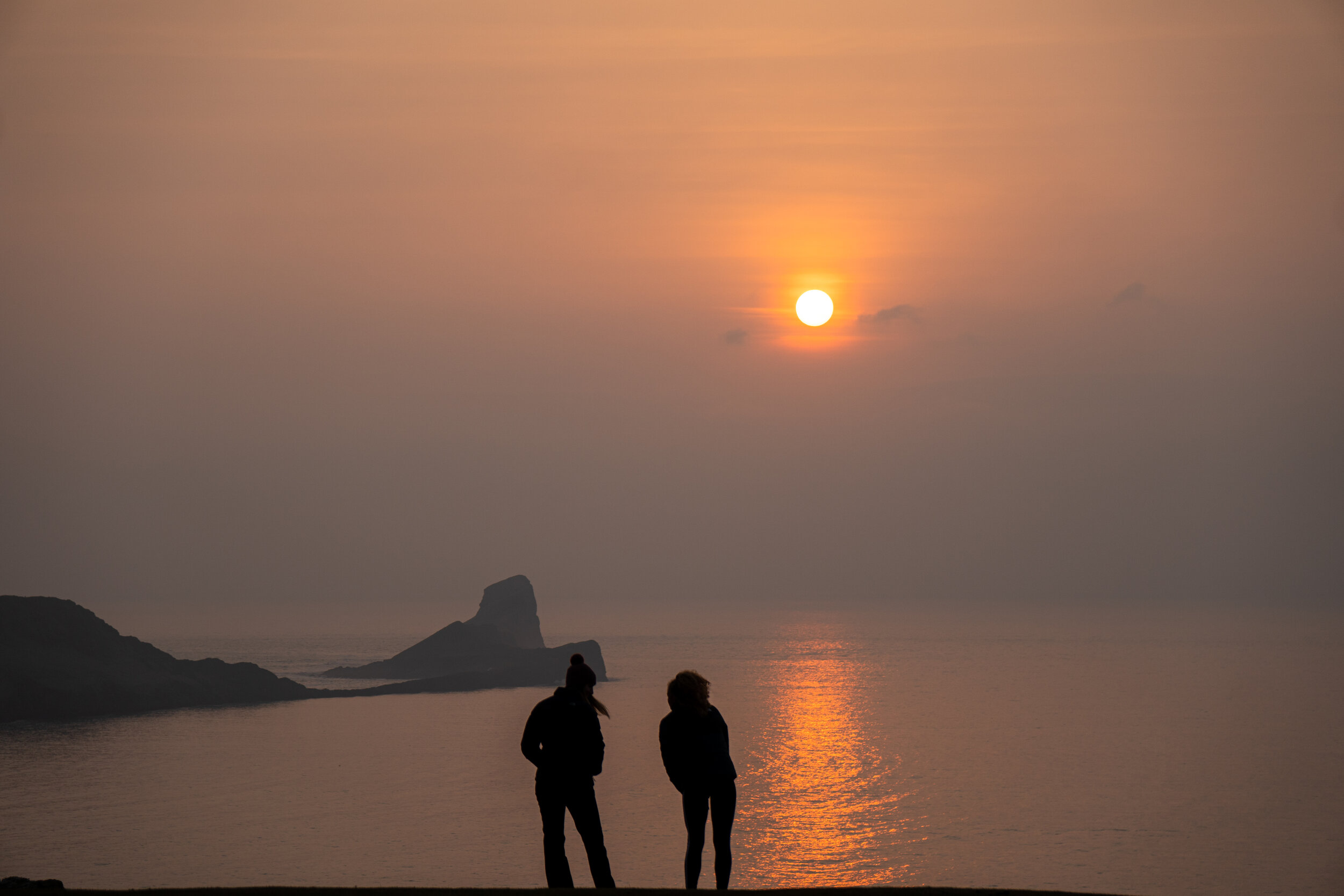
Worms Head, Gower Peninsula

Sunset at Worms head from the cliffs which line the headland
Dramatic coastal cliffs and sweeping panoramic vistas, words struggle to do this location justice.
The three mile stretch of Rhossili Bay is regularly voted as one of the best in Europe and has managed to make it into the top 10 beaches in the World. However It isn’t the beach which takes centre stage here, but rather the crown jewel of the Gower, worms head.
Located on the southwestern tip of the Gower Peninsula, Worms head is an one mile long, sea serpent shaped, tidal island situated several hundred yards off the headland.
Derived from the Norse word for 'Dragon’, it’s dramatic and awe inspiring presence is the poster image for the peninsula and attracts thousands of victors each year.
It's a location which still leaves me lost for words, despite having visited it on countless occasions. It's even more special when visited for sunset as you can see the sun drop directly below the horizon. Aim to head down in the late afternoon or early evening and take the time to stick around.
Check out my separate in-depth guide to Rhossili and Worms head below for all the details.


The outer head from devils bridge
Ynys Llandwyn, Anglesey

Designated as Wales’ first coastal National Nature Reserve back in 1955, this stunning outcrop of land is one of the most picturesque locations in the country.
It's a location I was completely transfixed on upon visiting and one I always make the time to visit when in North Wales.
Situated on the island is the Instagram worthy white Tŵr Mawr lighthouse and church of Saint Dwynwen - the Welsh patron saint of lovers.
Alongside the lighthouse, the island has several golden sanded coves which give you an incredible vistas looking back towards the mountain ranges of Snowdonia and the Llyn Peninsula.

How to reach the island
The closest car park is located behind Newborough beach, postcode LL61 6SG.
To reach it you first have to pass through a toll barrier then drive a mile through Newborough forest. You pay upon exit and are charged for the length of time you have stayed. It costs £2 for the first 2 hours then 40p for every additional 20 minutes. The maximum fee is £7 per 24 hours.
From the car park, the walk to the tip of Llanddwyn Island should take around 45 minutes via the shoreline. Make sure to check the tide times before you set off as the island gets temporarily cut off either side of high tide. If you do get stuck you will have to wade back through waist deep water. The tide times are available here;
I would recommend heading down in the late afternoon or early evening, taking the time to fully explore both the forest and island before staying for hopefully a memorable sunset.


Green Bridge of Wales & Elegug stacks, Pembrokeshire

The Green Bridge of Wales
A two for one special on one of the most remarkable sections of the Pembrokeshire coastline.
The Green Bridge of Wales is a 24m (78ft) high natural limestone arch located on the southern coastline of Pembrokeshire Coast National Park.
It’s an awe-inspiring coastal feature which defies logic & can easily be reached via a simple 200m walk from car park.
Although there’s a designated wheelchair friendly viewing platform built for visitors to photograph the arch, its best viewed by skirting the clifftop in front of it. Outside the breeding seasons of May to July those without a fear of heights can even venture down onto the arch to really appreciate its true scale.
Situated a couple of hundred yards down the coast are the equally impressive Elegug stacks.
Stack Rocks as its also known, are two imposing limestone stacks which protrude almost 20m from the sea floor.
They once formed part of the Pembrokeshire coastal path thousands of years of erosion has left them separated them from the mainland. Their isolated and predator free nature now means they serve as an important nesting location for many species of seabirds found on the Pembrokeshire coast.
For the photographers amongst you the locations south facing direction also makes it a great spot for sunrise alongside photographing the Milky way.

Elgug stacks - situated 400m down the coast from the Green Bridge of Wales
How to Reach the Green Bridge of Wales
There is a large car park (which is free), located less than 200m from both Elgug Stacks and the Green Bridge of Wales.
To reach the car park you have to drive 2.5km through a MOD military firing range. Unfortunately, this road can be closed off during certain times for training exercises. This will be clearly indicated as there will be a barrier and booth flying a red flag stopping you from accessing the road. To avoid a wasted trip, you can check that the road through the firing range is open to the public by calling the Pembroke Visitor Centre (+44 01437 776499) or Castlemartin Firing Range (+44 01646 662367).

The milky way over the Green bridge of Wales

The milky way over Elgug Stacks
Blue Lagoon, Pembrokeshire

A sunset drone shot of Blue Lagoon looking up the north Pembrokeshire coast
My favourite coastal feature in Pembrokeshire and one I never get tired of visiting.
Pembrokeshire's Blue lagoon is abandoned slate quarry filled with turquoise water on the north coast of the national park. Shut down in 1910, the seaward wall of the quarry was blasted open by fisherman in order to flood the mine and provide refuge for their boats.
The spectacular nature and coastal location of Blue lagoon has resulted in it being chosen as a stop on the Red Bull cliff diving series in 2012, 2013 & 2016. The events saw the world's best divers leap from a man-made platform, suspended 27 metres above the quarry. The diving board has since been removed but you can still swim across the quarry and jump in from the man made platforms on the other side.
For those wanting to stay dry, take the time to hike up and admire the lagoon from the cliffs above.
For the ramblers amongst you, I would recommend walking the coastal path northwards for a further 3km until you reach the quaint, picturesque fishing harbour of Porthgain. On route you’ll skirt around some of Pembrokeshire’s most dramatic and rugged coastline which towers over one-hundred feet above its turquoise clear waters. There is also the reward of some fantastic fish and chips and a pint at the end.

Sunset from Blue lagoon
How to reach Blue Lagoon
Parking is available at the nearby Abereiddi Beach, its free in the winter months but costs £4 otherwise. From here the lagoon is easily accessible via a 5 minute walk.
Alternatively you can park at the harbour of Porthgain and walk the coastal path southwards for 3km.


A drone shot looking back towards St Davids head
Three Cliffs Bay, Gower Peninsula

A sunrise drone shot looking back on Three Cliffs bay
Three Cliffs Bay is my favourite spot on the Gower and a spectacular location no matter the season.
Its distinctive coastal peaks and golden sands warrant a visit in itself. However when you add its winding green valley which is overlooked by the ancient ruins of Pennard castle then you have a place which is truly unique.
The real draw however is its iconic three peaks. Popular with rock climbers, the 20m limestone cliffs stand triumphantly in the middle of the bay and adorn postcards across the peninsula. There’s also a natural archway beneath the largest of the peaks which can be walked through at low tide.
The beach is lifeguarded during the busy summer months and is dog friendly year round making it a firm favourite with families.
The best place to view the iconic peaks from the dune covered headland which separates three cliffs from the neighbouring Pobbles bay. This is possibly one of the most photographed spots on the Gower and a great place to watch the sunset from. Another great location is from the other side of the bay just below Three Cliffs Holiday park. This view also makes for a great spot for sunrise especially if you can time it with high tide.
For a detailed guide to Three cliffs bay, including the best places to park and how to access it, check out my in-depth blog below.


The classic view from the headland above the cliffs

Pennard castle
Nash point, Glamorgan Heritage Coast

The dramatic sea cliffs of the Glamorgan heritage coast
Situated on the southern coastline of Wales, the Glamorgan Heritage Coast stretches 14 miles from Aberthaw to Porthcawl. With its dramatic costal cliffs, secluded coves, and awe inspiring views it is a must visit for coastal ramblers and seaside lovers alike.
Although any section of this coastline is worthy of a visit, it is the four magnificent miles between Nash Point and Dunraven Bay which encapsulate the rugged but majestical scenery of the Heritage Coast.
Situated just outside the village of St Donats, Nash point is a large bedrock beach lined with fossils and rock pools and backed by rugged cliffs. The dramatic shoreline can either be seen from the coastal path which hugs the clifftop above, or from the rocks below which are accessible for several hours either side of low tide.
Adding to the locations beauty is a 19th century, grade 2 listed lighthouse which still guards passing seafarers from the treacherous rocks below. Tours of the lighthouse are available but only by prior arrangement only.

How to reach Nash point
There is a situated right above the beach which has space for around 8-10 cars. If this is full you can pay £3 to park at the cliff top cafe directly in front of the car park which serves food, hot drinks, and has a public toilet. From here the beach is accessible via short 5 minute walk

Church Door Cove, Pembrokeshire
One of Pembrokeshire’s many geological wonders scattered across it’s rugged coastline.
Church door cove is an amphitheatre-shaped bowl containing a magnificent door shaped arch which has been cut into the towering cliffs by the forces of the ocean.
At mid to high tide the beach becomes cut off and consists of mainly large boulders, but as the tide drops away a beautiful, sheltered stretch of sand is revealed.
Next door to Church Cove are the golden sands of Shrinkle Haven beach. Unfortunately the steps leading down to the beach have been fenced off. However, the bay is accessible at low tide via Church door cove by either walking around the thin limestone headland or scrambling through a narrow and slippery cave.
Check the tide times and aim to head down as the tide is retreating from mid to low in order to get the maximum amount of time here.

Church door cove from the shoreline
How to reach Church Door cove
Free parking is available either at Manorbier YHA, postcode SA70 7TT, or 500m further along the road on the cliff top adjacent to the coastal path. From the car park Church door cover which is easily accessible via a short 5 minute walk which leads to the steep concrete and metal steps (140 in total) which drop down onto the bay.

St Cwyfan's Church, Anglesey
Possibly the most recognisable church on Anglesey.
St. Cwyfan's, which is more commonly known as the Church in the Sea , is a grade is a Grade II listed medieval church dating back to the 12th Century.
What makes this church so unique is its idyllic location. Perched on a tiny island called Cribinau and encircled by a sea wall, it is only accessible at low tide via purpose built rocky causeway. The church originally stood at the end of a peninsula between two bays, Porth Cwyfan and Porth China, however centuries of erosion has cut it off from the mainland turning it into an island.

How to reach the church
Free parking is available on the side of a narrow country lane just outside the village of Aberffraw. Parking is limited and turning points are few and far between so time your visit wisely.
The church and surrounding coastal path are not only beautiful but very remote, meaning you’re likely to find yourself undisturbed when visiting. If you did want to explore the surrounding area or extend your walk then to the south is Aberffraw beach and to the north is Cable Bay and Rhosneigr. Both are easily accessible along the Anglesey coastal path.

Sunrise over the church in the sea, Photo by Neil Thomas on Unsplash
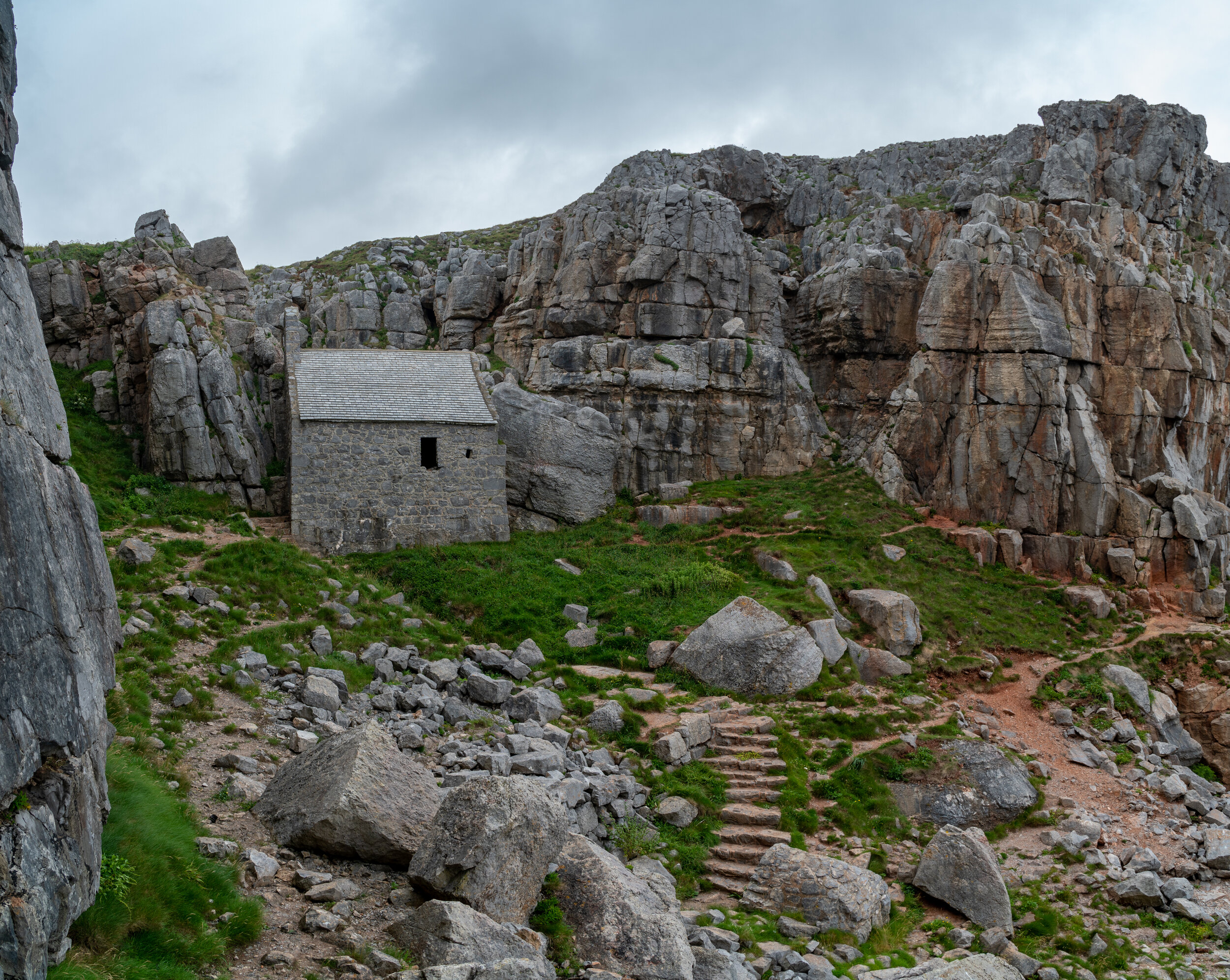
St Govan’s Chapel, Pembrokeshire
Although a man made feature, this historic gem has to be one of the most interesting and quaint features on the Welsh coast.
St Govans chapel is a tiny stone building carved into the limestone cliffs of the Pembrokeshire Coast. Dating back to 13th century the chapel was built to honour the hermit St Govan who lived here alone here during the 6th century.
The history of St. Govan is shrouded in mystery. He was believed to fleeing from some pesky Irish pirates when the cliffside allegedly morphed into a secret cave for him to hide in. After successfully evading his captors, Govan chose to set up a monastic hermitage in the cove and remained there for the rest of his life.
I prefer to believe that after the 6th century Welsh Coronavirus outbreak started he was forced to self isolate there due to Mark Drakefords distant relatives strict lockdown restrictions.
The view of the chapel from the rocks below
How to reach the chapel
Free parking is available less than 50 meters from the church steps (postcode SA71 5DR).
The chapel is reached by descending 52 stone steps, polished smooth by the feet of generations of visitors. After passing through the wonderfully atmospheric chapel you are able to head down and marvel at the structure from the rocks below.
Be warned that the car park is located within the confines of a military firing range. Unfortunately, as I have found out first hand, this road leading to the car park can be closed off by a booth and barrier during certain times for military training exercises.
To avoid a wasted trip, you can check that the road through the firing range is open to the public by calling the Pembroke Visitor Centre (+44 01437 776499) or Castlemartin Firing Range (+44 01646 662367).

the steps leading down to St Govans Chapel
Trefor Sea stacks, Llyn Peninsula
Located on the north coast of the Llyn Peninsula, Trefor stacks are several columns of granite which protrude from the Irish sea.
There are actually two sets of sea stacks on this delightful stretch of coastline, Ynys Fawr & Ynys Fach (which translates to big & small island). It is Ynys Fawr which is the more photographed of the two, especially around sunset.
What makes this location even more impressive is the peaks of Yr Eifl which loom directly above the stacks. This group of hills, known as the rivals in English, has three separate summits, the highest of which tops out at 561m.
The peaks not only house one of the most in-tact iron age hillforts in the UK, they also offer incredible panoramic views across the Llyn peninsula, Snowdonia, and Cardigan bay. And if the weather is really clear you can even see as far as the Isle of Man and the Lake District.
How to reach the stacks
The stacks are located several hundred yards down the coastline from the small fishing village of Trefor. Free Parking is available in front of the harbour and from here its a short half a mile westwards down the coastal path.

Trefor sea stack at sunset | Photo by Neil Thomas on Unsplash
There we have it, the 10 best coastal features in Wales. What do you think, have I missed any out, should any of these not be in here? Let me know in the comments below.
If you did find it helpful, I’d appreciate you giving it a share or giving me a follow on social media, every bit of support goes a long way.
For more travel, & photography inspiration around Wales check out my in-depth guides to each of my favourite regions below.

Find me on Instagram


